College of Engineering & Computing
As the research engine of the university, our mission is to reach preeminence in the classroom, laboratory and industry. With this in mind, we are pursuing innovations in education, research that is interdisciplinary and leads to entrepreneurial pursuits, and stronger community and industry engagement. We are offering new degrees and programs that will prepare our students for jobs of the future. We are expanding our outreach in the community and engaging with our partners and alumni in the industry to promote FIU engineering across the nation and to enhance post-graduation opportunities for our students.
SUPPORT OUR STUDENTS
GIVE NOW 
QuickLinks
Admissions
Degrees
Schools
Student Resources
Research
Connect
124
TENURE-TRACK FACULTY
$62m
INNOVATIVE RESEARCH
40
PATENTS
26
NSF EARLY CAREER AWARDS

Student Spotlight
Meet McNair Scholar and B.S. Mechanical Engineering student, Matty Sey.
Sey hopes to pursue a career in developing and advancing the next generation of nanomaterials that can change people’s lives for the better.
Faculty Highlight
FIU TECHNOLOGY HEADS TO INTERNATIONAL SPACE STATION
To help, FIU’s Plasma Forming Laboratory has developed an innovative coating material to shield structures.

Faculty Highlight
FIU technology heads to International Space Station
To help, FIU’s Plasma Forming Laboratory has developed an innovative coating material to shield structures.
37
MAJORS & DEGREES
We offer 14 bachelor’s, 16 master’s, and seven doctoral degrees
+2,000
DEGREES AWARDED
10
FULLY ONLINE COURSES
Students can choose from 10 fully online degree programs and tracks
19
CONTINUING ED COURSES
We offer several courses that benefit students, alumni, professionals and non-traditional students
CEC News


Come to Mama: Ph.D. student asks Shark Tank investors to fund her baby bottle innovation
For most entrepreneurs, showcasing their innovation on Shark Tank, one of the nation’s highest-rated reality TV shows, is something they can only...

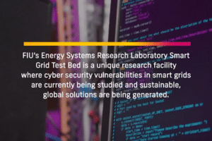
Ransomware can hide in the websites you upload files to
FIU cybersecurity researchers warn websites that request access to your files might be able to bypass antivirus software and carry out major...
CEC News
Come to Mama: Ph.D. student asks Shark Tank investors to fund her baby bottle innovation
For most entrepreneurs, showcasing their innovation on Shark Tank, one of the nation’s highest-rated reality TV shows, is something they can only...
Ransomware can hide in the websites you upload files to
FIU cybersecurity researchers warn websites that request access to your files might be able to bypass antivirus software and carry out major...

American Express offers jobs, internships to 25 FIU students
The students, the majority of them women studying computer science, spent three weeks at the company as part of a new micro-internship program...
")